
What is the difference between location intelligence, geomarketing and GIS?
Three terms that are often used as if they meant the same thing. They overlap, but they answer different questions and suit different people.
GIS is the software that stores, analyses and draws geographic data. Location intelligence is the use of location data to make decisions anywhere in a business. Geomarketing is the commercial branch of location intelligence: customers, stores, markets and territories. A geomarketing tool is location intelligence packaged, with its data, for those questions.
This page compares the three terms. For what geomarketing is, where it comes from and which questions it answers, start with what is geomarketing?
What does each term mean?
| Term | What it is | Who uses it | A typical question |
|---|---|---|---|
| GIS | Software for storing, editing, analysing and mapping geographic data | GIS analysts, planners, surveyors, environmental scientists | “What lies within this boundary, and how is it shaped?” |
| Location intelligence | Using location data to inform decisions across a business | Logistics, insurance, telecoms, retail, public services | “Where is our risk, our demand or our cost concentrated?” |
| Geomarketing | Location intelligence applied to markets, customers, stores and territories | Retailers, franchisors, sales and marketing teams, consultants | “Where should we open, and who will come?” |
The three nest inside each other. GIS is the engine: the software that can draw any boundary and measure anything inside it. Location intelligence is the habit of asking “where?” before a decision, in any department. Geomarketing is that habit applied to selling.
A study of supermarket location strategies defines geomarketing as the use of geographic information systems for commercial decisions, and finds that models of spatial interaction — how shoppers divide between stores by distance — are the ones businesses use most.
Source: Baviera-Puig, Buitrago-Vera and Escriba-Perez (2016), “Geomarketing models in supermarket location strategies”, Journal of Business Economics and Management 17(6).
How did GIS, location intelligence and geomarketing develop?
Geographic information systems date from the 1960s, when governments built them to manage land and natural resources. For decades they stayed specialist tools, run by trained analysts on expensive workstations with data bought and cleaned by hand.
The ideas of geomarketing are older than the software. Reilly’s law of retail gravitation dates from 1931 and Huff’s probability model from 1963; what changed is that computers made them cheap to run on real streets and real populations.
Location intelligence is the business name that spread once map data and computing became ordinary. It describes the outcome — a decision informed by place — rather than the tool, which is why it now covers everything from delivery routes to insurance pricing.
The newest step puts the data and the methods together behind a simple interface, so that someone with a business question, not a GIS degree, can get the answer. That is what most people now mean by a geomarketing tool.
Why does the method matter more than the label?
The same address, 576 Chapel Street, South Yarra, Melbourne VIC, measured two ways on 7 October 2026. A circle is what any map tool draws first; a drive time on the road network is what a geomarketing tool draws by default.
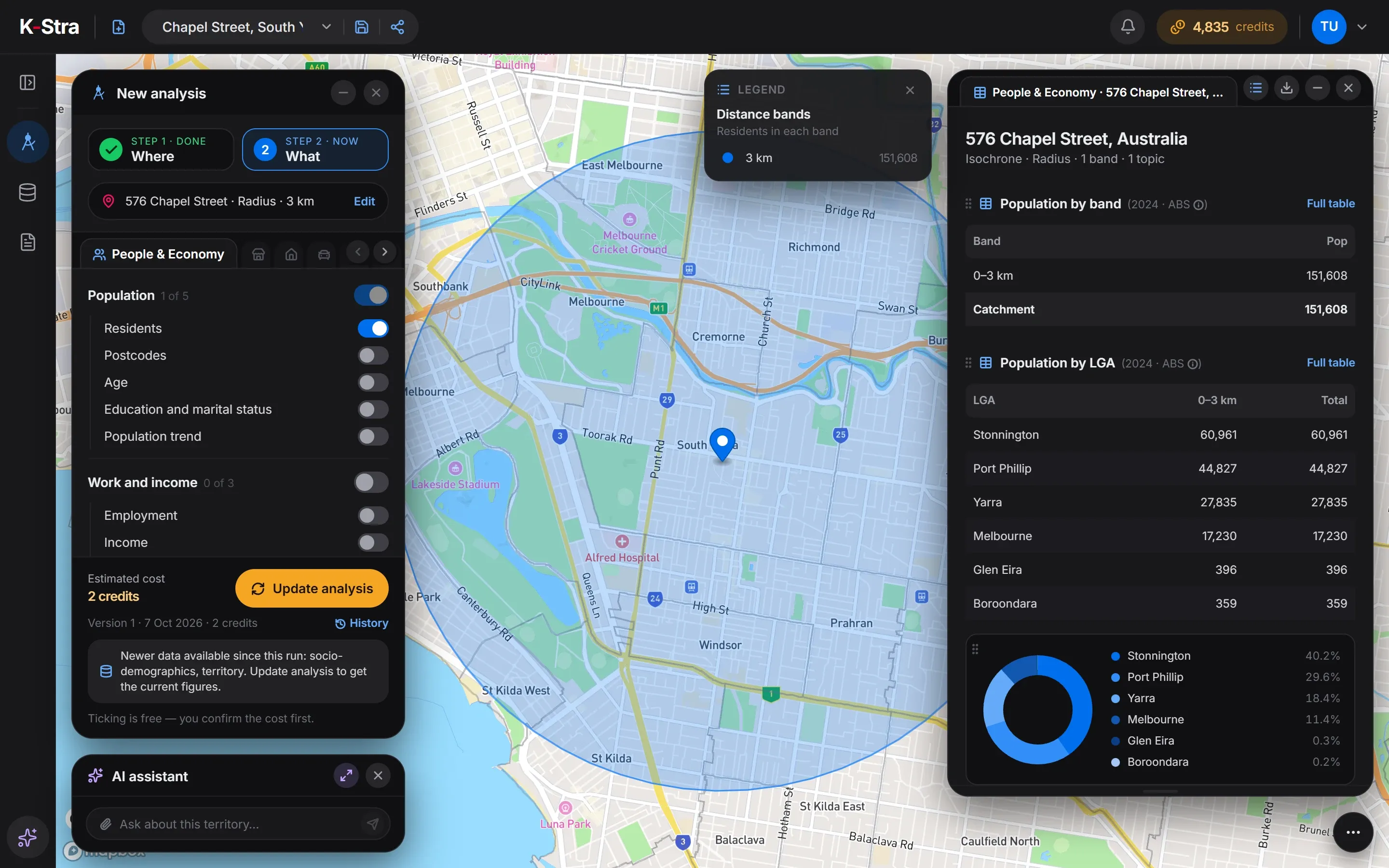 3 km radius
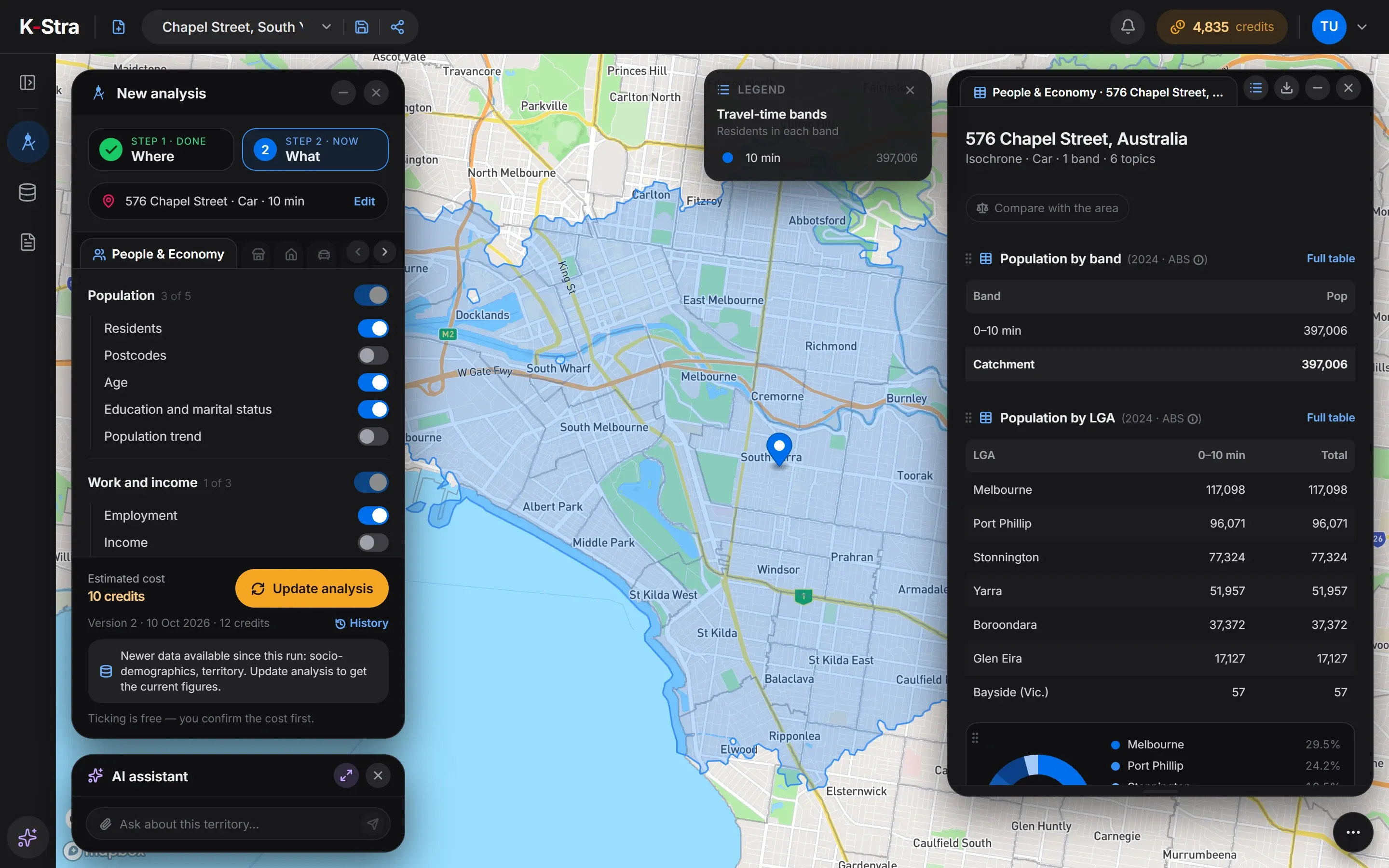 10 minutes by car
The drive time holds 2.6 times the residents of the circle, because inner Melbourne’s roads carry a car well beyond 3 km in ten minutes. Both numbers are correct; they answer different questions.
A GIS can draw either shape. The difference a geomarketing tool makes is that the realistic one is the default, residents are already placed on addresses, and the result is a count a business can use rather than a layer to interpret.
Source: a 3 km radius and a 10-minute drive in average traffic from 576 Chapel Street, South Yarra, Melbourne VIC. ABS population, sex and age 2024 (annual estimates); families and dwellings from the 2021 Census. Spread onto addresses with the 2021 SA1 mesh. K-Stra analysis of 7 October 2026.
Which one does a business need?
A GIS
If you have analysts, your own spatial data and questions no packaged tool covers, such as environmental studies or infrastructure planning.
A location intelligence platform
If location runs through many departments — fleets, risk, networks — and a data team will build dashboards on top of it.
A geomarketing tool
If the questions are commercial — where to open, who lives there, who competes, how to split territories — and the answer is needed this week.
Most retailers, franchisors and consultants fall in the third group. The questions to ask any of these tools are listed in the guide to choosing a geomarketing tool.
What else do people ask about location intelligence?
Is geomarketing the same as location intelligence?
Geomarketing is part of location intelligence. Location intelligence covers every use of location data in a business, from delivery routes to insurance risk; geomarketing is the part that deals with customers, stores, markets and territories.
Do I need GIS skills for geomarketing?
Not with a tool built for it. Traditional GIS software expects you to find the data, load it and build each analysis. A geomarketing tool comes with the population, spending and business data already joined, and turns a business question into a map and a table.
What data does location intelligence use in Australia?
Mostly public statistics from the Australian Bureau of Statistics — population, Census, income, spending — combined with a road network, business locations, property listings and the company’s own records, such as stores, customers and sales by postcode.
Why do two location tools give different numbers for the same address?
Because of the area and the data behind it. A 3 km circle and a 10-minute drive around the same Melbourne address hold 151,608 and 397,006 residents. Population year, the way residents are placed on the map and the road speeds used all change the count too.
Location intelligence
without the GIS.
Type an address, draw a drive time and see residents, spending and competitors in one view.
Open the app — free to exploreExploring the map is free