
How does K-Stra calculate a drive-time catchment?
What happens between typing an address and reading how many people live within ten minutes of it.
K-Stra calculates a drive-time catchment on a graph of the Australian road network with 14,525,695 nodes. Dijkstra’s algorithm spreads out from the address along the roads, with a speed for each class of road, and the catchment is made of the address points reached in time. Residents are then added up one address at a time.
What happens when K-Stra draws a catchment?
- Step 01
From the address to the road
The search starts at the nearest address on a road you can drive. The short gap from your point to that road is counted at 30 km/h.
- Step 02
Along the network
Dijkstra’s algorithm visits the junctions in order of travel time, adding the time of each stretch of road, until the longest band is reached.
- Step 03
Around the buildings
Every building has a cell of land around it. The catchment is the union of the cells of the addresses reached, not a smoothed outline.
- Step 04
Residents, one address at a time
Each address carries its share of residents and spending, so the total of a catchment is the sum of the addresses inside it.
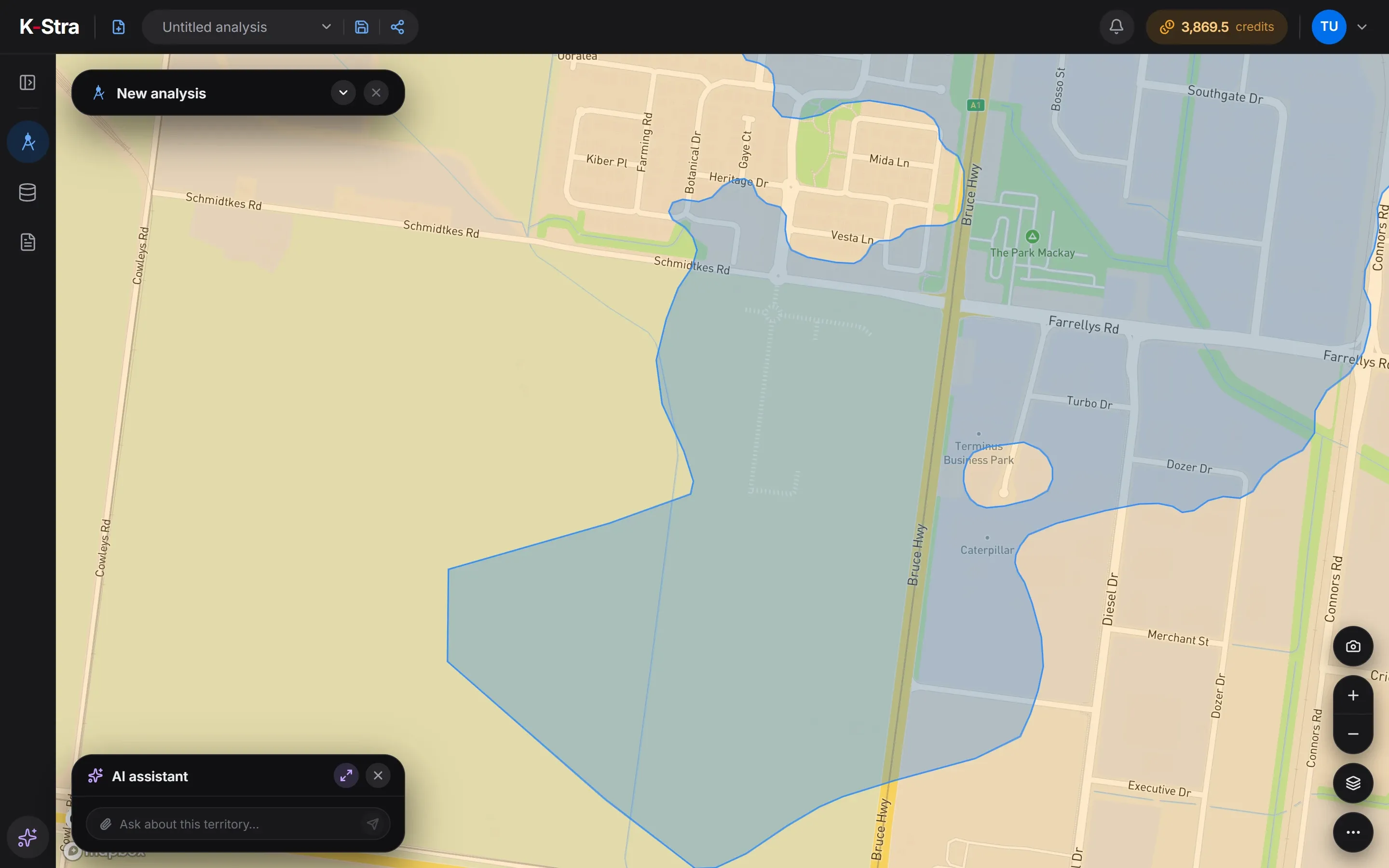 The edge of a band · Mackay
What is the road network made of?
The graph in use was built on 12 October 2026: 14,525,695 nodes and 33,291,162 road segments across Australia, including Christmas Island, the Cocos Islands, Norfolk Island and Lord Howe Island.
Each segment keeps its length, its road class, whether it is one-way and a driving speed worked out from its class, its speed limit and its surface. Travel time comes from length and speed when a catchment is drawn, so the same graph serves driving, driving without motorways and walking.
Base speeds by road class come first. They are lowered to the posted limit and on unsealed roads, and in built-up areas they fall to between 33 and 65 km/h, depending on how close together the addresses are.
On foot, K-Stra uses 4 km/h, ignores one-way rules, leaves out motorways and adds footpaths. Without motorways, motorways are removed from the search, not just slowed down.
| Road class | Base speed |
|---|---|
| Motorway | 130 km/h |
| Trunk road | 110 km/h |
| Primary road | 90 km/h |
| Secondary road | 70 km/h |
| Tertiary road | 50 km/h |
| Residential street | 40 km/h |
How does heavy traffic change a catchment?
Heavy traffic multiplies the travel time of every stretch of road by a factor that depends on its class. Local roads slow down more than motorways, so a heavy-traffic catchment shrinks most in town.
| Roads | Factor | Longer by |
|---|---|---|
| Motorways | × 1.22 | +22% |
| Trunk and primary roads | × 1.30 | +30% |
| Secondary and tertiary roads | × 1.35 | +35% |
| All other roads | × 1.50 | +50% |
The two profiles are fixed: there is no live traffic and no rush-hour timetable. Use heavy traffic to test whether a site still reaches its customers on a bad day, and average traffic for the everyday picture.
Traffic changes travel times, not distances. A catchment measured in kilometres along the road is the same in both profiles.
Isochrone, isodistance or radiusHow are residents counted in a catchment?
K-Stra spreads residents and spending onto 14.5 million address points and adds up the ones reached. An address is either inside or outside: no census area is cut in proportion to its surface, which is what keeps a 10-minute catchment honest at its edges.
The method, the sources and the checks against official council totals are on the page about the territory.
How does K-Stra estimate demand and competition?
For a sector, the same address points carry three more figures, worked out in advance for the whole country and refreshed when stores open or close.
Demand
The yearly spending on the sector that residents can reach within its usual travel time, calculated for each SA1 area. Each address shows the figure of its area, so demand is read, not added up.
Competition
An index of how strongly the existing stores pull on each place: bigger stores pull more, and the pull fades with travel time. It is an index, not a percentage.
Opportunity
A Huff model, the standard retail gravity model in which larger and closer stores draw more of each area’s spending, asks how much spending a new store of median size would draw at each place against the stores already there. Market gap scores 100 for a typical place.
What the model leaves out
Only residents’ spending is modelled. Workers, commuters, tourists, passing traffic and online sales are not, so city centres, tourist areas and stations come out lower than they are. The results are made for comparing places of the same sector in the same area.
How long does a calculation take?
Bands of 5 and 10 minutes by car were drawn in about half a second and a 30-minute drive in under three seconds, in tests by the K-Stra team in September 2026. Times grow with the length of the drive and with the number of buildings reached.
The engine runs on a dedicated server in Sydney and keeps the whole graph ready in its files. A new graph is loaded when the territory data is updated.
Coverage and infrastructureQuestions about the engine
Does K-Stra use live traffic?
No. There are two fixed profiles, average and heavy traffic, applied to every road class; there is no live traffic and no traffic by time of day. Heavy traffic lengthens travel times by 22% on motorways and up to 50% on local roads.
Where does the road network come from?
K-Stra builds its own graph from map data of roads, buildings and addresses: the one in use was built on 12 October 2026 and covers Australia with its external territories.
Why does the catchment have straight edges in some places?
Because it is made of the cells of land around buildings. Where a building stands alone in a large lot, such as a warehouse or a farm, its cell is large and has straight sides; in a suburb the cells are small and follow the streets.
How are my own stores placed on the network?
Each point is attached to the nearest address on a drivable road within 1,000 metres, leaving out motorways and footpaths. It happens automatically and for free as soon as the point has coordinates; a point farther than that from any road is left off the network.
Where does the calculation run?
On K-Stra’s dedicated server in Sydney. The routing engine is written in C++ and runs inside the application, so a catchment never leaves the server to be calculated.
Type an address.
Watch the roads decide.
Draw travel-time bands on any Australian address for free, then count who lives inside them with a free account.
Open the app — free to explore40 credits when you sign up · no card required