
How do I draw fair territories for my franchisees?
A territory is a promise to a franchisee. Drawing it from measured residents and drive times makes the promise fair, and easy to explain.
Fair franchise territories give each franchisee a similar market, measured in residents or households, within a reasonable drive of the outlet. Build them from small areas such as postcodes, assign each to the nearest outlet by drive time, then move areas across borders until every territory is within an agreed gap of the average.
Why are franchise territories so often unfair?
Territories are usually drawn around the first outlets, on a map with a marker pen or a radius. A radius in an inner suburb holds several times the people of the same radius on the fringe.
The obvious fix, giving each area to the nearest outlet, makes it worse: outlets close together split a dense market, and the outer one gets everything up to the edge of the map.
And the number of units is often decided before the market is measured. If a franchisee needs a certain number of households to make a living, that number should decide how many territories there are.
is the least time a prospective franchisee must have the franchisor’s disclosure document before signing. Territories need to be settled, and explainable, before that clock starts.
ACCC, “Franchise disclosure document”, Franchising Code of Conduct in force from 1 April 2025 (page read on 1 November 2026).
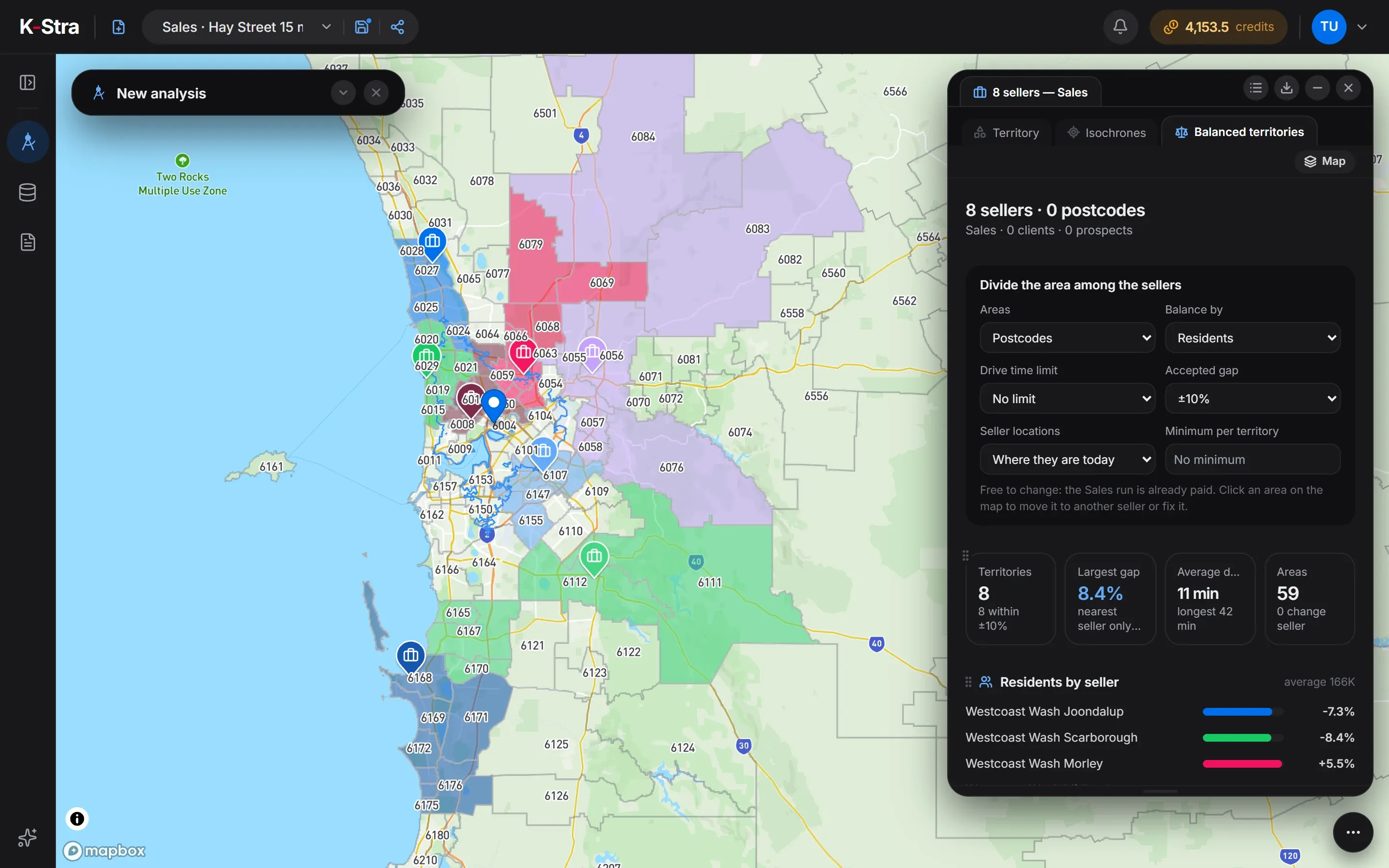 Sample data · Perth
How do you draw franchise territories, step by step?
Choose what a territory must hold
Residents, families or, if you have them, customers. Pick the measure that drives demand for your format.
Choose the building blocks
Postcodes are what franchise agreements usually list; suburbs or smaller statistical areas give finer borders.
Start from the outlets
Each outlet keeps the area it stands in, and every other area goes to the outlet nearest by drive time.
Even them out
Move areas across the borders, one at a time, until every territory is within the agreed gap of the average and still in one piece.
Set a floor
Decide the smallest market a franchisee can live on. If a territory cannot reach it, the area holds fewer units than you thought.
Adjust by hand, then fix
Local knowledge still counts: move or lock the areas you must, and let the rest balance around them.
Write the list into the agreement
A territory defined as a list of postcodes is easy to check and hard to dispute.
What data do you need to draw franchise territories?
Only the outlets. Residents, families, areas and drive times come with the analysis; customers are optional.
Your outlets
A CSV or Excel file with one row per franchisee: a code, a name and coordinates or the address of the outlet.
File formats and limitsResidents and families
ABS population estimates at 30 June 2025, by postcode, suburb or smaller area.
Population dataAreas and their borders
Postcodes, suburbs, SA1 to SA3 areas and councils, with which areas touch which.
Territory dataCustomers, if you have them
A customer file with a location and any numeric column, to balance on your own business instead of residents.
Customer mapping
K-Stra runs on a dedicated server in Sydney: your datasets, your analyses and your results stay in Australia. Map tiles, payments and sign-in never see your files. Three steps can: geocoding sends only the address text, and only after you confirm; the AI assistant reads column names and values when you ask it about a dataset; email notifications carry figures from your analysis.Where your data lives. Mark a dataset “session only” and it is deleted 24 hours after upload.
How do you draw franchise territories in K-Stra?
Territories are a view of the Sales analysis, where each outlet is entered as a seller. Once the run is paid, every change of settings is free.
- Load the outletsUpload them into My Data and pick them as sellers in a Sales analysis. 5 credits per outlet.
- Balanced territoriesChoose the areas, the measure, an optional drive-time limit and the accepted gap: ±5, ±10 or ±20%.
- Today or proposedBalance around the outlets where they are, or let K-Stra propose sites where the residents are and see how far each outlet would move.
- Floor and fixesSet a minimum per territory, move or fix areas by hand, and export the list of areas by franchisee.
Every territory stays in one piece and each outlet keeps the area it stands in. The result lists, for every franchisee, the areas, the residents, the gap from the average and the average and longest drive to the outlet.
What do balanced franchise territories look like in numbers?
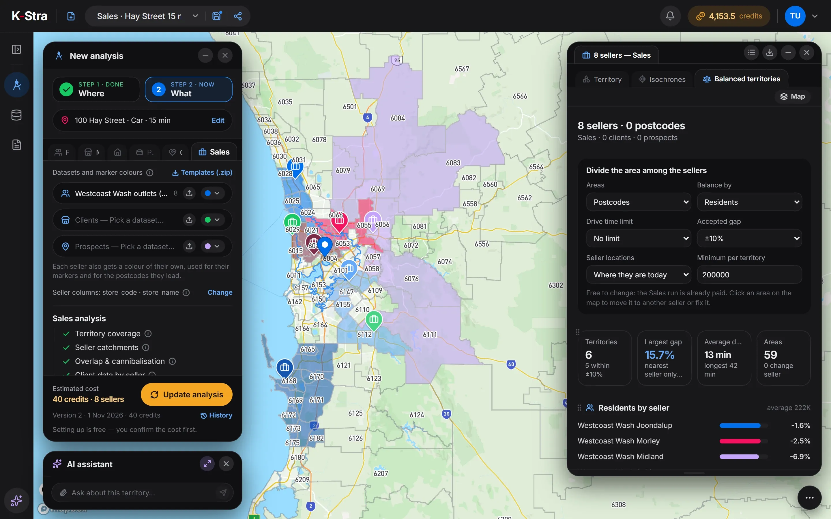
A sample franchise of 8 outlets in Perth WA, balanced on residents over 59 postcodes and 1,329,353 people. Every territory lands within ±10% of the average, about 166,000 residents, with an average drive of 11 minutes. The last column sets a floor of 200,000 residents per territory.
| Outlet | Postcodes | Residents | Gap from average | Average drive | With a 200,000 floor |
|---|---|---|---|---|---|
| Joondalup | 6 | 154,030 | −7.3% | 8.1 min | 217,944 |
| Scarborough | 7 | 152,146 | −8.4% | 7.7 min | no territory |
| Morley | 10 | 175,277 | +5.5% | 9.9 min | 216,077 |
| Midland | 8 | 178,870 | +7.6% | 13.4 min | 206,292 |
| Subiaco | 8 | 166,952 | +0.5% | 10.7 min | 215,332 |
| Cannington | 6 | 171,691 | +3.3% | 9.3 min | 256,352 |
| Armadale | 5 | 170,453 | +2.6% | 15.6 min | no territory |
| Rockingham | 9 | 159,934 | −3.8% | 14.5 min | 217,356 |
Sources: sample outlets of a fictional franchise in a K-Stra sample account; ABS population at 30 June 2025 by postcode; K-Stra Balanced territories of 1 November 2026, postcodes of the councils where the outlets stand plus Cambridge, Kalamunda, Kwinana, which join them into one area.
What do the territories say about the Perth network?
The outlets are well spread: balanced around where they stand today, all 8 territories fit within ±10%. Armadale and Rockingham pay for it in distance, with average drives of 15.6 and 14.5 minutes against under 8 for Scarborough.
Letting K-Stra propose the sites instead gives a similar balance, with a largest gap of 9.9%, and a slightly shorter average drive of 10 minutes. The proposed sites sit on average 5 km from today’s outlets: the network is close to where it should be.
The floor changes the answer. If a franchisee needs at least 200,000 residents, the area holds 6 territories, not 8: Scarborough and Armadale drop out and their postcodes go to the neighbours.
With six, the largest gap rises to 15.7%, on Cannington, and 5 of 6 territories stay within ±10%. That is the kind of trade-off worth settling before a territory is promised in writing.
The franchise and its outlets are invented for this example and loaded into a K-Stra sample account; postcodes, population and drive times are real.
How much does it cost to draw franchise territories?
The price depends only on the number of outlets. The size of the area, the number of postcodes and every new balancing you try cost nothing more.
Outlets without coordinates are geocoded at 1.5 credits per 1,000 addresses; the import shows that cost before you confirm.
- Sales analysis, 8 outlets5 credits per outlet40 credits
- Outlet file import1 credit per 10,000 rows1 credit
- Balancing, proposed sites, minimum, moves by handFree
- These territories= 41 credits
- ≈ A$63 at the Single report pack rate of A$1.53 a credit; less with larger packs and monthly plans.
The cost appears before the run starts, and nothing is charged if it fails.
What else do people ask about franchise territories?
Should franchise territories be equal in area or in people?
In people, or in households. Equal areas put a few thousand residents in an outer territory and hundreds of thousands in an inner one. Equal markets with a drive-time limit are fairer to both franchisees.
How do I know how many franchises an area can hold?
Set the minimum market a unit needs and divide the area again. If two outlets cannot reach the minimum, the area holds two units fewer, and the balancing shows which ones.
Can territories follow postcodes?
Yes. Postcodes are the default building block, and a territory comes out as a list of postcodes you can attach to the agreement. Suburbs, SA2 and SA1 areas, SA3 areas and councils are also available.
What if an area has to stay with a particular franchisee?
Click it on the map and fix it to that franchisee, or move it to another one. The rest of the map balances around it, and a fixed area never changes hands.
Can I balance on my own figures instead of residents?
Yes, with a file of customers: territories can be balanced on the number of customers or on the sum of any numeric column, such as orders or revenue per customer.
Territories your franchisees
can check for themselves.
Load your outlets, choose the measure and see territories balanced on real residents and drive times.
Open the app — free to exploreSales analysis 5 credits per outlet, balancing free