
How do you bring your own data into K-Stra?
Your stores, customers and territories, next to the national data and on the same map.
Your own data goes into My Data: CSV or Excel files up to 100 MB, tables pasted from a spreadsheet, KML, KMZ or GeoJSON boundaries, or administrative areas copied with their figures. K-Stra reads the columns, geocodes addresses on request and places each point on the road network, ready for maps and analyses.
What can you import into My Data?
Four ways in, one place to keep them. Separator, encoding and column types are read from the file, so it does not need a fixed layout.
| Source | Formats | Limits |
|---|---|---|
| File | CSV or TXT with any common separator, Excel .xlsx and .xlsm (the first worksheet) | 100 MB per file, up to 500 columns, no row limit |
| Paste | A table copied from a spreadsheet or a web page | The same checks as a file |
| Boundaries | KML, KMZ or GeoJSON in WGS84 coordinates, one kind of shape per dataset | Up to 100,000 shapes per file |
| Administrative areas | Any of the nine levels from the whole country to SA1, with K-Stra figures for each area | Optionally only inside a state, a council or a postcode |
Each person can run 20 imports and upload 500 MB a day, one import at a time. Old .xls workbooks and shapefiles are not read: save them as .xlsx, CSV or GeoJSON first. Importing needs a free account.
What happens when you import a list of stores?
A sample file of 10 stores of an invented rural supplies chain across the Darling Downs, Queensland: code, name, street address, town, postcode, format, floor area and opening date. No coordinates, so every address has to be geocoded.
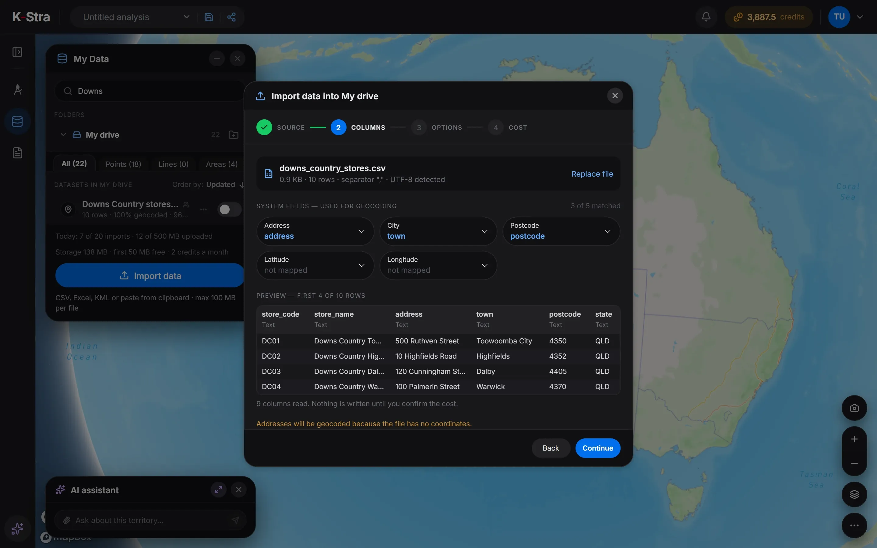 Step 2 · Columns
- Step 1
Source
Drop the file or paste the table, and give the dataset a name and a folder.
- Step 2
Columns
Check the address, town, postcode or coordinate columns K-Stra has matched, and the type of each column.
- Step 3
Options
Geocode after the import, place the points on the road network, or keep the data for 24 hours only.
- Step 4
Cost
See the price before anything is written: here 2 credits, one for the import and one for geocoding 10 addresses.
On-screen text
My Data · Import. Your file, on the map. 10 stores of a sample chain in the Darling Downs, from a CSV file. CSV, Excel or KML, from My Data. 10 rows and 9 columns, read in place. Address, city and postcode, recognised. Geocoded and placed on the road network. 2 credits, confirmed before it runs. 10 of 10 geocoded, around Toowoomba. 4 at low confidence, to check. Fix the address or drop the pin, free. From a spreadsheet to the map. Sample file: 10 stores of a fictional chain in the Darling Downs, Queensland.
How accurate is geocoding in K-Stra?
All 10 stores of the example were placed on the map, and K-Stra flagged 4 of them for a check. The flags are the useful part: they tell you which rows to look at before you trust an analysis.
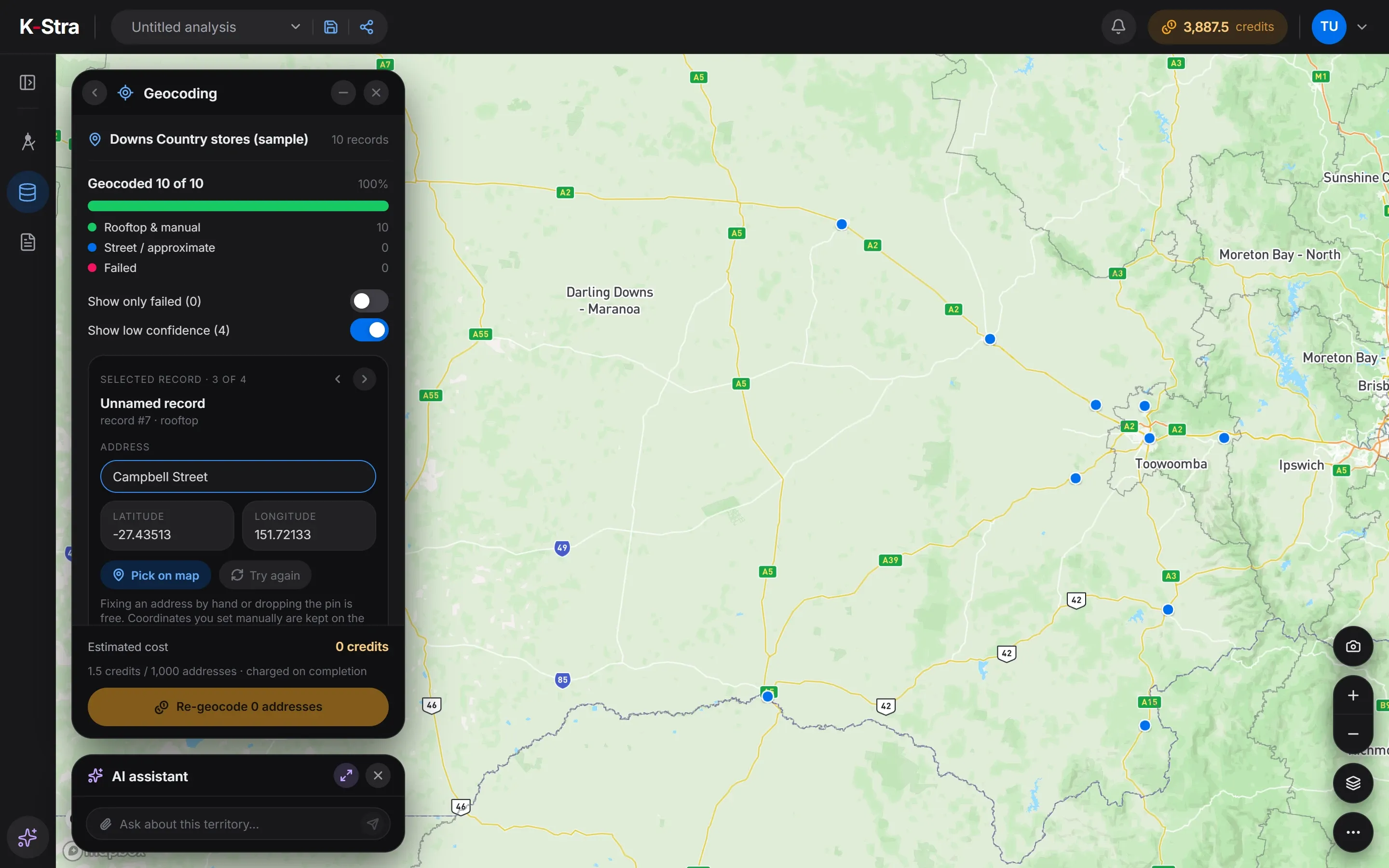 Geocoding
Two addresses were left imperfect on purpose: a street with no number, Campbell Street, Oakey QLD 4401, and a misspelt town, Yandilla St, Pittswroth QLD 4356. Both landed in the right town, and both were among the 4 flagged records, with two complete addresses in Toowoomba and Highfields.
Every row keeps its status (rooftop, approximate, failed or manual), its accuracy and its confidence. When no match falls inside the postcode of the row, the point goes to the centre of the postcode and is marked approximate.
Coordinates you type or set on the map are kept the next time the dataset is geocoded, and points are attached to the nearest drivable road within one kilometre.
K-Stra runs on a dedicated server in Sydney: your datasets, your analyses and your results stay in Australia. Map tiles, payments and sign-in never see your files. Three steps can: geocoding sends only the address text, and only after you confirm; the AI assistant reads column names and values when you ask it about a dataset; email notifications carry figures from your analysis.Where your data lives. Mark a dataset “session only” and it is deleted 24 hours after upload.
Where can you use your data in K-Stra?
On the map
Colour points, areas and lines by any column, filter them by area or by value, and show only the rows you need.
Maps and thematicsYour stores in Markets & Brands
Up to 500 of your points in a coverage analysis, and up to 100 existing stores next to the candidate sites of a comparison.
Store network planningSales territories
Sales reps, clients and prospects from three point datasets, with any filter you saved on them.
Sales territory mappingLoyalty cards
Card transactions imported with their own template become the catchment, market share and penetration of each store.
Loyalty card analysisTables, charts and maps built on your datasets can go into reports. When a report is shared outside your team, the parts built on your own data are removed before anyone opens it.
How do you keep datasets organised and private?
Datasets live in folders under My drive: drag a dataset onto a folder to move it, search by name, and open the table to correct a value, filter rows or add new rows and columns with Add data. Deleting rows is free and cannot be undone.
A dataset is visible to your team by default. Make it private and only you see it, or share it with named people in the team; viewers read, editors change. Every organisation’s data is kept apart from every other.
Good to know before you upload
- Datasets must not contain personal or sensitive information: use a postcode or an internal code per customer, never a name, an email or a phone number.
- A point is moved by typing its coordinates or with Pick on map, not by dragging it on the map.
- An export of the table covers the rows loaded on screen, 500 at a time with Load more.
- The map draws up to 50,000 points of one dataset; analyses use all of them.
What does My Data cost?
You pay to bring data in and to keep it beyond the free allowance. Everything you do with it afterwards on the map costs nothing.
| Action | Credits | Note |
|---|---|---|
| Importing a file | 1 credit per 10,000 rows | Minimum 1 credit. A failed or stopped import pays only for the rows already written. |
| Geocoding addresses | 1.5 credits per 1,000 addresses | Charged when the run ends; a stopped run pays for the addresses already processed. The same address is never paid for twice. |
| Placing points on the road network | Free | Automatic as soon as a point has coordinates. |
| Administrative areas with figures | 1 credit per 1,000 values | Plus the areas, priced like the rows of a file. |
| Storage | 2 credits per 100 MB a month | The first 50 MB of each organisation are free. |
| Editing, deleting, sharing, exporting | Free | Fixing a record by hand or on the map is free too. |
Storage is charged on the 1st of each month on the previous month’s average. If it goes unpaid, the datasets are suspended and deleted after 90 days, with an email warning before.
Questions about My Data
Which file formats can I import into K-Stra?
CSV and TXT files, Excel .xlsx and .xlsm workbooks (the first sheet), tables pasted from the clipboard, and KML, KMZ or GeoJSON for boundaries. Old .xls workbooks must be saved as .xlsx or CSV first, and shapefiles exported to GeoJSON.
What does geocoding send outside K-Stra?
Only the text of the address: the address, town and postcode columns of the rows that have no coordinates, with a filter for Australia and New Zealand. Sales, card codes and every other column stay on the server in Sydney. Geocoding starts only after you confirm its cost.
Can my datasets contain customer names?
No. Datasets must not contain personal or sensitive information, so remove names, emails, phone numbers and private addresses before uploading. A postcode or an internal code per customer is enough for every analysis in K-Stra.
What happens to a dataset marked as temporary?
It is deleted 24 hours after upload, with its tables. Use it for a file you need only for one working session.
Who can see my datasets?
By default the members of your team; you can make a dataset private, visible only to you, or share it with named people in the team. Viewers can read it, editors can change it, and no other organisation ever sees it.
Your stores,
on real numbers.
Sign up free, import a file and see the price of the import before anything is written.
Open the app — free to explore40 credits when you sign up · no card required