
Where should a bank branch or insurance office be?
A branch is a trip people plan, and each one has to be where it matters. Here is how to measure who a branch serves, and who it serves alone. The worked example is bank branches in Dubbo; the same method applies to insurance agencies and post offices.
Place a bank branch or insurance office by counting the residents within about a ten-minute drive, especially older residents who still bank in person, then the branches already serving them per 10,000 residents against the council, the state and Australia. For a network, ask which residents each branch covers alone before deciding where to open or close.
Which financial services does K-Stra map?
K-Stra has three sectors in this group: bank branches, insurance agencies and postal services. Each has its own demand from ABS household spending and its own reach, and each can be analysed on its own or put together on one map.
They are services, so the question is less where to compete and more whom to cover. That is why this group leans on Coverage and the Closure plan as much as on the sector analysis.
| Sector in the app | Locations | What it counts |
|---|---|---|
| Bank branches | 4,337 | Bank and credit union branches. |
| Insurance agencies | 3,522 | Insurance agencies and brokers. |
| Postal services | 5,207 | Post offices and postal outlets. |
Source: the Finance & Services group in the sector list of the K-Stra app on 1 November 2026, with the names the app uses; business catalogue of 23 October 2026, built from public online business listings. The counts here are the whole catalogue, as on the Australia pages; the national figure in the per 10,000 table of the example below counts only the locations K-Stra can place on an Australian address, so it can be a few places lower, which moves its rate by at most a hundredth.
Which numbers matter most for a branch?
Residents within a 10-minute drive
The K-Stra model measures bank branches on a 10-minute drive. A branch is a trip people plan, not one they make every day.
In the app: the Where step and the Demand map, which counts the spending reachable from each point.
Older residents
People who still bank at the counter tend to be older than those who bank on a phone. The share of residents over 65 tells you how much a branch is still needed.
In the app: People & Economy, Age: age groups of the catchment against Australia.
Branches per 10,000 residents
Australia has 1.57. Regional centres sit above it because their branches serve whole districts; outer suburbs often sit far below it.
In the app: the density table: catchment, council, state and Australia side by side.
Residents each branch covers alone
In a network, the branch that matters is the one whose residents have no other branch within reach. Closing it leaves them without one; closing a branch two streets from another does not.
In the app: Coverage and the Closure plan, branch by branch.
Other ways in
Post offices and insurance agencies are often what remains in a town. They change how far residents really are from a counter.
In the app: the Postal services and Insurance agencies sectors, or the neighbouring categories.
What data do you need to plan branch locations?
Branches, post offices, residents and their age, already loaded. Your own branches can be imported or picked from the map.
Every branch and office
4,337 bank branch locations, 3,522 insurance agencies and 5,207 postal outlets, from public online business listings.
Business and competition dataResidents by age
ABS population estimates at 30 June 2025 by age and sex, spread address by address.
Population dataIncome and spending
Income and consumption indices and household spending from the ABS, per area.
Work, income and spendingYour network
Your branches from a spreadsheet in My Data, or picked from the catalogue, as points for Coverage.
My Data
K-Stra runs on a dedicated server in Sydney: your datasets, your analyses and your results stay in Australia. Map tiles, payments and sign-in never see your files. Three steps can: geocoding sends only the address text, and only after you confirm; the AI assistant reads column names and values when you ask it about a dataset; email notifications carry figures from your analysis.Where your data lives. Mark a dataset “session only” and it is deleted 24 hours after upload.
How do you analyse branch locations in K-Stra?
Markets & Brands with Bank branches as a whole sector shows every branch and the density; Coverage then measures your own network branch by branch.
- SectorMarkets & Brands, whole sector, Bank branches: every branch, density and best locations, for 40 credits.
- CoverageYour branches and others’ with a drive time each: residents covered, shared and covered alone, for 5 credits per branch.
- PlanThe Closure plan ranks your branches by the residents each covers alone; the Opening plan ranks candidates by the new residents they add.
What does a branch analysis show?
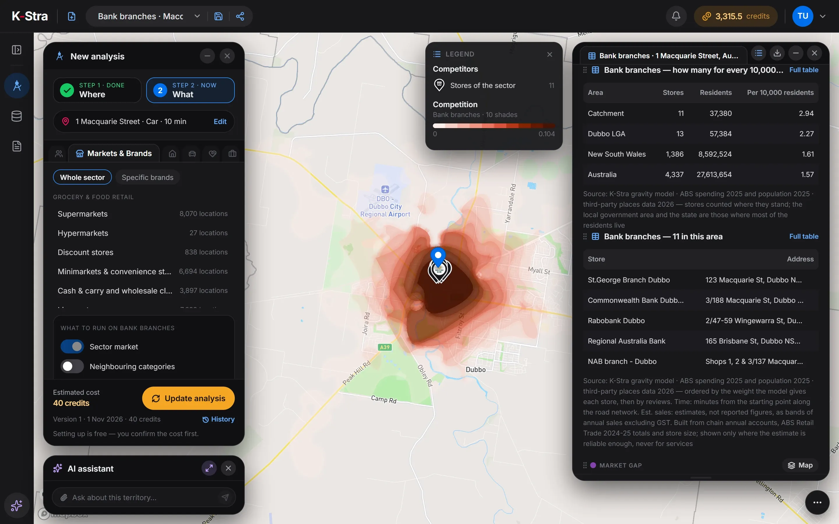
Bank branches within 10 minutes by car of 1 Macquarie Street, Dubbo NSW: 11 branches for 37,380 residents, 2.94 per 10,000 against 1.57 in Australia. All 11 stand within two minutes of the starting point, in the centre of Dubbo.
| Area | Branches | Residents | Per 10,000 residents |
|---|---|---|---|
| Catchment | 11 | 37,380 | 2.94 |
| Dubbo (council) | 13 | 57,384 | 2.27 |
| New South Wales | 1,386 | 8,592,524 | 1.61 |
| Australia | 4,337 | 27,613,654 | 1.57 |
Sources: K-Stra analysis of 1 November 2026: bank branches within a 10-minute drive in average traffic of 1 Macquarie Street, Dubbo. Businesses: K-Stra places catalogue, October 2026. Residents: ABS population estimates at 30 June 2025. Spending: ABS national accounts, 2024–25.
Are Dubbo’s branches in the right place?
For a regional centre, the density is what you would expect: 2.94 branches per 10,000 residents, almost twice New South Wales at 1.61, because the branches serve a district far larger than the 37,380 people within ten minutes. The Dubbo council area has 2.27.
What stands out is the cluster: every branch is in the centre. The opportunity map points to the residential edges of town, near 1 Potter Close, 181 Fitzroy Street and 75 Wheelers Lane, where residents are furthest from a branch.
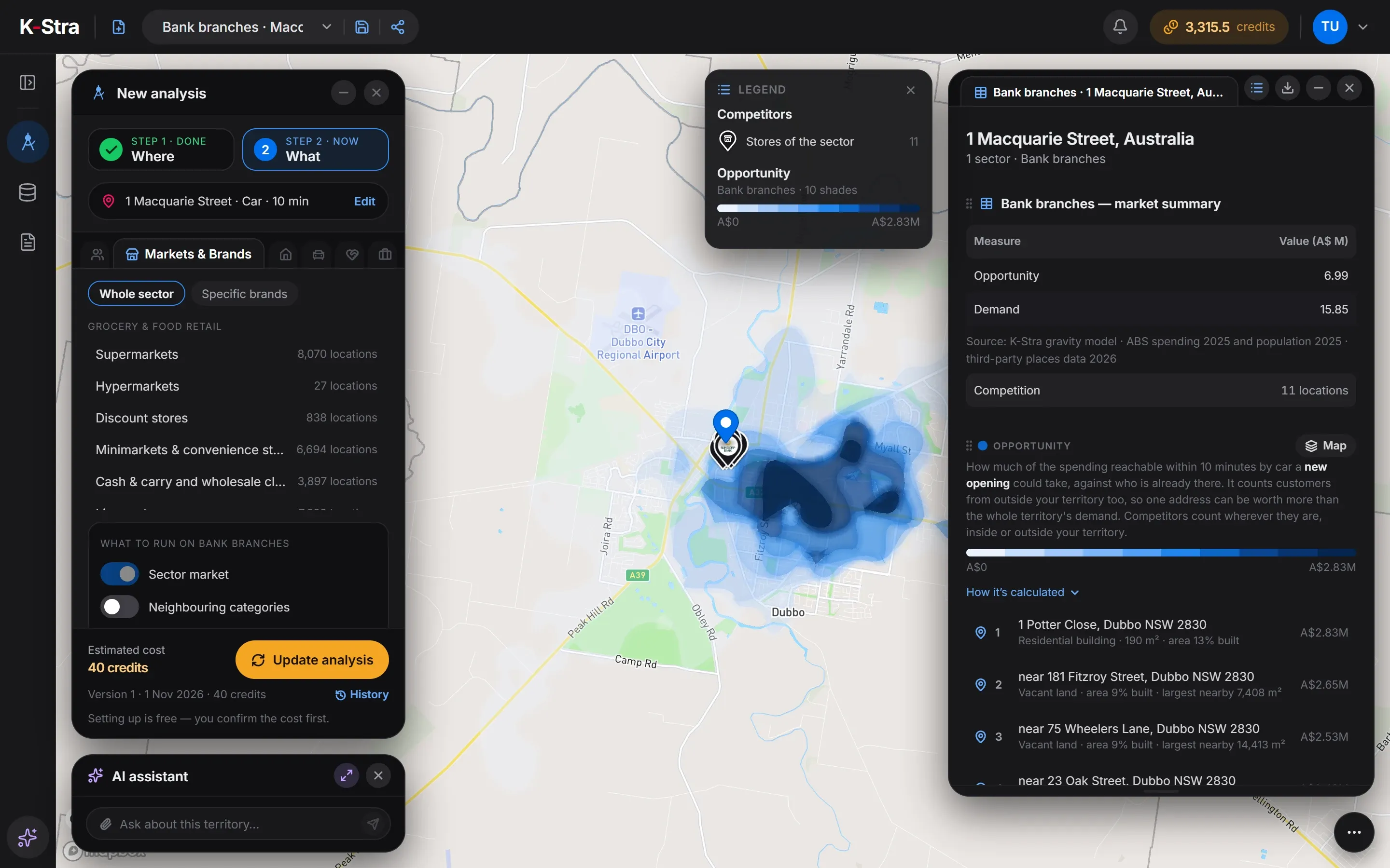 Opportunity · Dubbo
How much does a branch analysis cost?
The Dubbo example cost 40 credits. A network of 40 branches in Coverage costs 200 credits, with the Closure and Opening plans included.
- Markets & Brands, Bank branchesper sector, any area40 credits
- Maps, tables and exports of the resultsFree
- Total= 40 credits
- ≈ A$61 at the Single report pack rate of A$1.53 a credit; less with larger packs and monthly plans. A new free account’s 40 welcome credits cover it.
Optional, not in the total
- People & Economy, Ageper topic+ 2 credits
- Coverage of your networkper store or candidate+ 5 credits
The estimate appears before the run starts, and a run that fails costs nothing.
What do people planning a branch network ask next?
Which branches should we keep?
Rank closures by the residents they would leave without a branch within reach, and openings by the new residents they add.
Store network planningDo our branches overlap?
Measure how many residents two branches share and how many each covers alone.
Cannibalisation analysisWho lives around this branch?
Age, households, income and spending of the residents, against the council, the state and Australia.
Demographic analysis
What else do people ask about branch locations?
How many bank branches are there per resident in Australia?
4,337 bank branch locations for 27,613,654 residents: 1.57 per 10,000, or one for every 6,367 Australians, in the K-Stra catalogue of October 2026. Insurance agencies and post offices are separate sectors.
Can K-Stra show which residents a branch closure would leave without a branch?
Yes. Coverage takes up to 500 branches, yours and others’, with a drive time for each, and the Closure plan ranks your branches by the residents each one covers alone, so you can see who would be left without a branch within reach. It costs 5 credits per branch.
Are post offices counted as banking points?
They are a sector of their own, Postal services, in the same group. In many towns the post office also offers counter banking, so it is worth adding next to the branches when you judge access.
Does K-Stra have data on bank customers or deposits?
No. K-Stra has residents, age, households, income and spending from the ABS, and the locations of branches. Customer, account and deposit data stay with the bank; it can be imported as counts by postcode, without personal details.
Does K-Stra show the estimated annual sales of branches?
No. Bank branches, insurance agencies and post offices are services, and services never have an estimated annual sales band in K-Stra: the estimate is for existing retail stores only, as a band with its confidence.
See who each branch
really serves.
Type an address, pick Bank branches and read residents, density and the gaps on one map.
Open the app — free to exploreExploring the map is free; you pay only for the analyses you run