
How many people live in Western Australia, and how much do they spend?
The fastest-growing state is also one of the most concentrated: four in five residents live in Perth, and the rest are spread across a third of the continent.
Western Australia had 3,044,382 residents at 30 June 2025 and grew 14.5% from 2019 to 2025, on average 2.41% a year, the fastest of any state or territory. Greater Perth holds 80.6% of them. With a consumption index of 106.0, residents spend about A$55,725 each a year, above the Australian average.
What are the key figures for Western Australia?
| Indicator | Western Australia | Australia |
|---|---|---|
| Residents, 30 June 2025 | 3,044,382 | 27,613,654 |
| Average yearly change, 2019–2025 | 2.41% | 1.50% |
| Residents added since 2019 | 384,757 | 2,278,828 |
| Area | 2,526,633 km² | 7,688,095 km² |
| Residents per km² | 1.2 | 3.6 |
| Share in Greater Perth | 80.6% | — |
| Median age | 37.9 | 38.5 |
| Aged under 15 | 17.9% | 17.4% |
| Aged 65 and over | 16.3% | 17.5% |
| Income index | 106.4 | 100.0 |
| Consumption index | 106.0 | 100.0 |
| Spending per resident, a year | A$55,725 | A$52,582 |
| Resident spending, a year | A$169.6 billion | A$1,452.0 billion |
| Families (Census 2021) | 703,116 | 6,730,182 |
| Homes rented (Census 2021) | 30.3% | 33.6% |
| Flats and apartments (Census 2021) | 8.9% | 19.6% |
- Residents: ABS Estimated Resident Population at 30 June 2025, by council (2025 boundaries). Change: ABS Estimated Resident Population by council, 2019 to 2025; average yearly change as in the K-Stra area dashboard.
- Age: ABS population by five-year age group at 30 June 2025; median age worked out from the age groups. Capital: Greater Capital City Statistical Areas (ABS ASGS Edition 3), residents counted by K-Stra on the address points inside them.
- Indices: Income index from ABS Personal Income 2022–23 (tax data), measured or estimated; consumption index derived from it; 100 = Australia. Spending: Spending per resident from the consumption index and ABS national accounts (5204.0) for 2024–25. Housing and families: ABS Census 2021 (families, rented homes, flats and apartments).
Where do people live in Western Australia?
Greater Perth counts 2,452,786 residents, 80.6% of the state, spread along the coast from Two Rocks to Mandurah. Only 8.9% of the state’s homes were flats or apartments in 2021: Perth is a city of houses, and most catchments are drawn by car.
Outside Perth, the Bunbury region has 210,962 residents and the Wheat Belt 149,597. The northern outback has only 102,732, but an income index of 126.8 and a median age of 33.6.
| Area (capital city, then SA4 regions) | Residents 2025 | Share | Median age | Income index |
|---|---|---|---|---|
| Greater Perth | 2,452,786 | 80.6% | 37.4 | 107.6 |
| Bunbury | 210,962 | 6.9% | 43.2 | 92.2 |
| Western Australia – Wheat Belt | 149,597 | 4.9% | 45.9 | 90.6 |
| Western Australia – Outback (South) | 128,305 | 4.2% | 39.3 | 106.9 |
| Western Australia – Outback (North) | 102,732 | 3.4% | 33.6 | 126.8 |
Residents counted by K-Stra on the address points inside each area; median age from the five-year age groups, income index weighted by residents. The income index comes from ABS personal income tax data for 2022–23, measured for councils and SA2 areas and estimated elsewhere; 100 is the Australian average.
One city has a page of its own, with residents within 15, 30 and 45 minutes of the centre and incomes by postcode: Greater Perth.
Which councils in Western Australia are growing fastest?
Serpentine-Jarrahdale, on Perth’s southern edge, grew 29.0% from 2019 to 2025, on average 4.84% a year, and Kwinana 4.74% a year. The City of Perth, the small central council, grew 4.41% as apartments filled, and Swan, in the north-east, 4.31%.
Augusta Margaret River, in the South West, is the one fast-growing council outside Perth, at 4.04% a year. No council over 20,000 residents shrank; Kalgoorlie-Boulder grew least, at 0.34%.
| Council | Residents 2019 | Residents 2025 | Change a year | Rank |
|---|---|---|---|---|
| Serpentine-Jarrahdale | 31,410 | 40,531 | 4.84% | Fastest |
| Kwinana | 44,700 | 57,422 | 4.74% | Fastest |
| Perth | 28,214 | 35,673 | 4.41% | Fastest |
| Swan | 148,672 | 187,090 | 4.31% | Fastest |
| Augusta Margaret River | 16,235 | 20,170 | 4.04% | Fastest |
| Kalgoorlie-Boulder | 30,636 | 31,268 | 0.34% | Slowest |
| Greater Geraldton | 40,173 | 42,882 | 1.12% | Slowest |
| Bunbury | 33,267 | 35,730 | 1.23% | Slowest |
Councils with more than 20,000 residents in 2025. Average yearly change = (residents 2025 ÷ residents 2019 − 1) ÷ 6, on 2025 council boundaries.
How much do residents of Western Australia spend, and on what?
Residents of Western Australia spend A$55,725 each a year, about A$3,143 more than the average Australian. The richest councils are the mining towns: Karratha, in the Pilbara, has an income index of 156.9 and Kalgoorlie-Boulder 135.5, both above every Perth council with more than 20,000 residents.
| Category | Per resident, WA | Per resident, Australia | Total, WA (A$ million) |
|---|---|---|---|
| Food and non-alcoholic beverages | A$5,151 | A$5,032 | 15,682 |
| Alcoholic beverages, tobacco and narcotics | A$1,559 | A$1,509 | 4,746 |
| Clothing and footwear | A$1,927 | A$1,869 | 5,867 |
| Housing, water, electricity, gas and other fuels | A$13,409 | A$12,788 | 40,822 |
| Furnishings, household equipment and routine household maintenance | A$2,443 | A$2,243 | 7,437 |
| Health | A$4,081 | A$3,823 | 12,424 |
| Transport | A$5,901 | A$5,558 | 17,965 |
| Information and communication | A$1,010 | A$956 | 3,075 |
| Recreation, sport and culture | A$5,816 | A$5,380 | 17,706 |
| Education services | A$2,056 | A$1,862 | 6,259 |
| Restaurants and accommodation services | A$4,842 | A$4,447 | 14,741 |
| Insurance and financial services | A$4,409 | A$4,146 | 13,423 |
| Personal care, social protection and miscellaneous goods and services | A$3,121 | A$2,969 | 9,502 |
| All categories | A$55,725 | A$52,582 | 169,648 |
Spending per resident from the consumption index and ABS national accounts (5204.0) for 2024–25. Spending of residents, wherever it happens; visitors are not included.
How many businesses of each kind does Western Australia have?
Western Australia has fewer hairdressers, restaurants and real estate agencies per 10,000 residents than the national figure — 8.06, 10.82 and 4.24 against 9.31, 12.17 and 5.34 — and more fuel stations, 4.27 against 3.74, as befits long distances.
| Sector | Locations in WA | Per 10,000 residents | Australia |
|---|---|---|---|
| Supermarkets | 829 | 2.72 | 2.92 |
| Pharmacies | 804 | 2.64 | 2.63 |
| Gyms & fitness centers | 2,077 | 6.82 | 7.06 |
| Bars & cafés | 3,358 | 11.03 | 12.00 |
| Restaurants | 3,293 | 10.82 | 12.17 |
| Hairdressers | 2,454 | 8.06 | 9.31 |
| Childcare & early learning | 1,410 | 4.63 | 5.24 |
| Aged care & retirement living | 740 | 2.43 | 2.50 |
| Fuel stations | 1,300 | 4.27 | 3.74 |
| Real estate agencies | 1,292 | 4.24 | 5.34 |
| Hotels & accommodation | 3,754 | 12.33 | 15.11 |
K-Stra places catalogue, October 2026, as the app classifies each business; residents at 30 June 2025. A higher count per resident can mean smaller outlets, visitors or a crowded market: the catchment of each site tells which.
What can you see about Western Australia without an account?
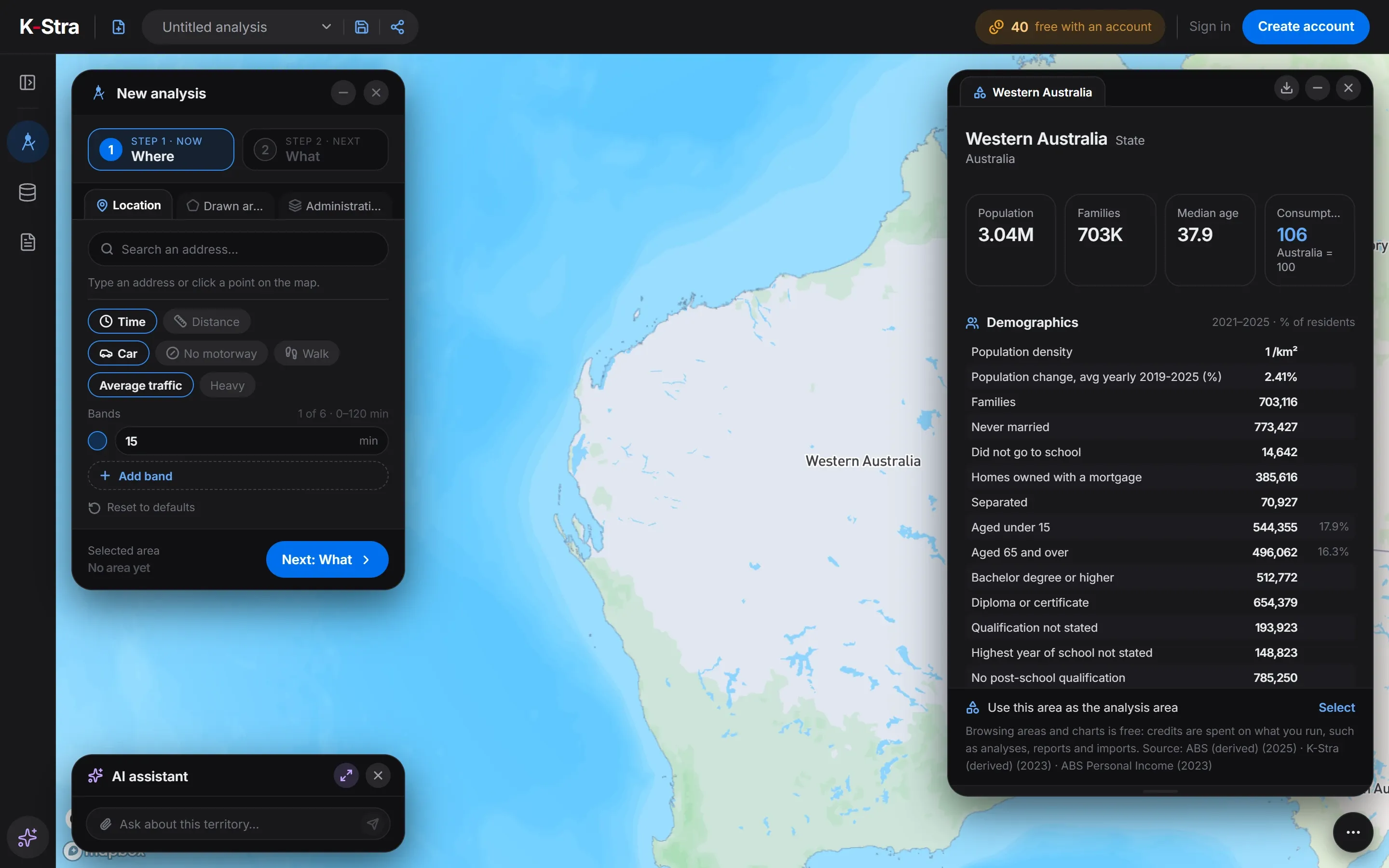 No account needed
On the map of Australia, a click on “Western Australia” opens this dashboard; zooming in, the same click works on every council, postcode and suburb in WA. Browsing them costs nothing.
Figures for the whole of Western Australia are a starting point: credits start when you measure the catchment of one of its addresses — the residents within a drive, their spending and the competitors already there.
What does this mean for choosing a location in Western Australia?
Higher spending per head and fast growth make Western Australia an attractive market, but the growth is almost all in Perth’s outer suburbs, where a site can open before its residents arrive. Timing matters as much as place: a site that is too early waits for its market.
Because Perth is low-density and car-based, catchments are wide and drive times matter more than distance. Two sites five kilometres apart can share most of their residents.
The mining towns earn the most but are small and remote, and depend on the cycle of the industry. For most formats they are single-site decisions, not part of a network.
What else do people ask about Western Australia?
What is the population of Western Australia?
3,044,382 at 30 June 2025 (ABS estimate), up from 2,659,625 in 2019. Greater Perth accounts for 2,452,786.
Which is the largest council in Western Australia?
Stirling, in Perth’s inner north, with 254,821 residents, followed by Wanneroo with 246,147. The City of Perth itself has only 35,673.
Is Western Australia richer than the rest of Australia?
On average, yes: its income index is 106.4 and its consumption index 106.0, with 100 as the Australian average. The gap comes largely from the mining regions: Greater Perth on its own sits at 107.6.
Open Western Australia
on the map.
The app opens on the state: click a council for its free dashboard, or draw a drive time around a site in Perth’s growth areas.
Open the app — free to exploreBrowsing areas and dashboards is free